ROMAN GOLD MINING IN THE „KARTH“, EASTERN ALPS, AUSTRIA
Research project, financed by the Austria Science Fund (FWF, Project P 30790-G25)
Select language
Sprachauswahl


Survey and cartography
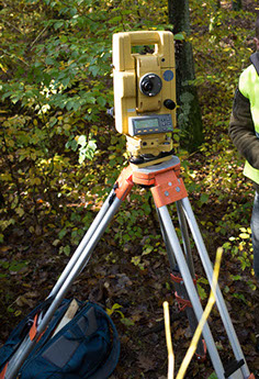
In current archaeology accurate and detailed survey has become an important tool. Not only to accurately find the 3D location of finds and features but also to document the relative spatial relations and to follow the progress of fieldwork. Just for this purpose to start with it is important to do a proper survey of the fieldwork area and excavation trenches. Additionally, in this project an engineering survey is the key to better understand properties, function and capacities of the hydraulic mining structures. What is the volume of the reservoirs, what is the capacity of the channels and their gradient? All this will help with the interdisciplinary interpretation of the various archaeological, topographic and geological features.
It is planned to apply terrestrial (total station, dumpy level) as well as satellite-based surveying techniques (different variants of GNSS) depending on needs and feasibility.
Further works are a comprehensive graphical post processing of all excavation and geophysical survey results. This will be done by extensive use of a geographical information system (GIS). Made available high-resolution LIDAR data will be included, processed and analysed as part of that GIS.
Contact:
Frank N. Stremke M.A.
D-28755 Bremen
Homepage: stremke-archaeology.net